.png)
UPDATING TEMSFORD NEW TOWN'S SPATIAL STRATEGY

Updated: Jun 13
Professor Doug Clelland and Dr Nigel Moor explore the opportunities Temford New Town can offer but identify current problems to overcome.
Tempsford is the only stand-alone new town among the government’s candidates. Its location within the Oxford-Cambridge Corridor has significant economic potential. It will surround a station with intersecting E-W and N-S links.
The new town can contain science and technology industries, commerce, social infrastructure and 40,000 homes. At present there seems no robust political ambition to achieve this. In the weeks ahead government should appoint someone to lead a team to bring an exemplary place into existence.
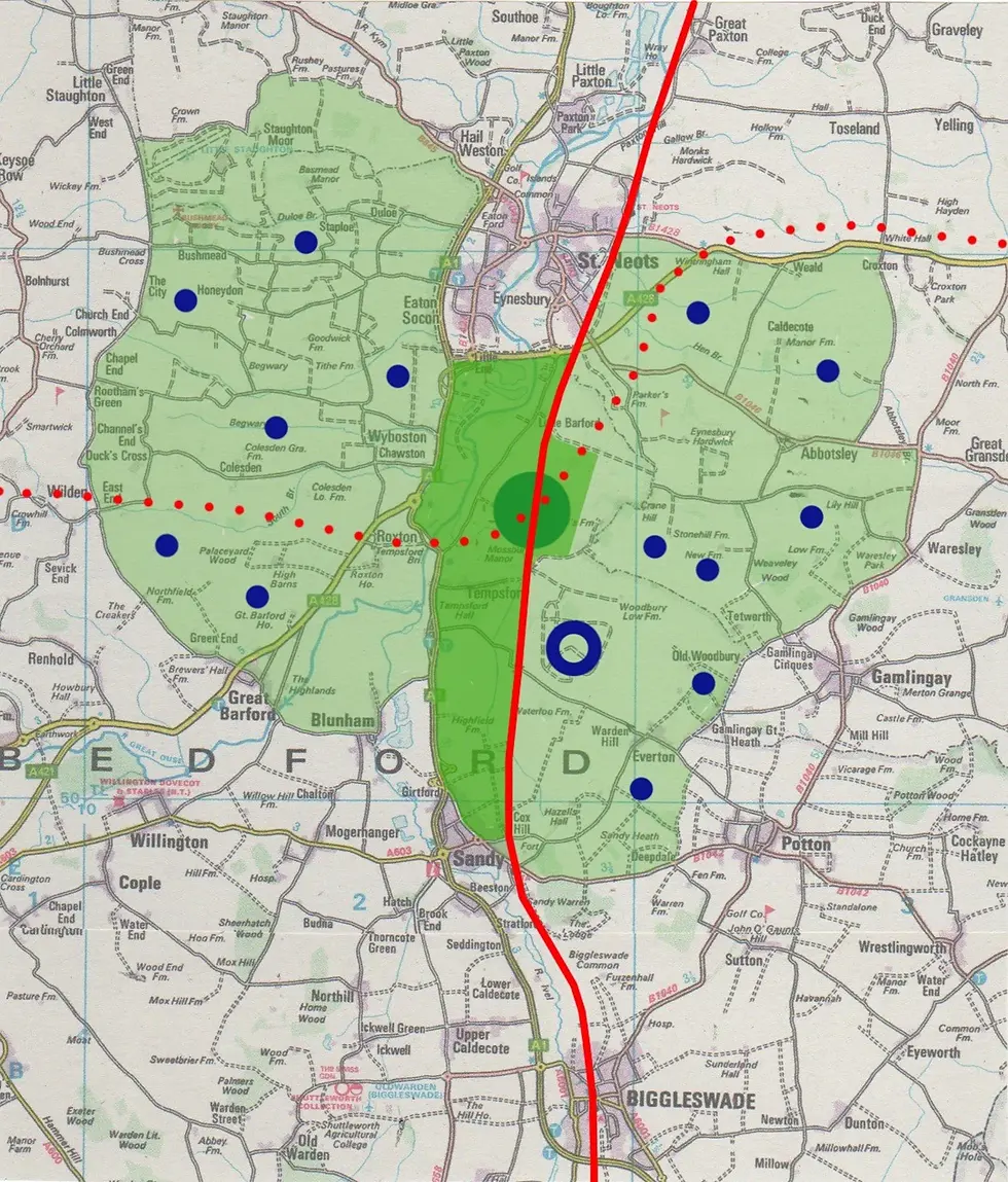
Linear centre with peripheral satellites
Tempsford can be an exemplary statement about the quality of British planning, design and development, addressing and delivering all necessary agenda topics to deliver a fully sustainable, internationally notable settlement.

Preliminary spatial strategy
Key
A: A421 dual carriageway
B: EWR – adapted alignment 1C
1: Interchange – with related functions and direct connection to the main public square
2: Middle town of mixed uses including housing
3: ‘Downpour’ parks with ‘end of street’ kindergartens, sports and leisure
4: Upper town with housing ‘micro districts’ carefully integrated with existing settlements and natural features
5: Lower town – as for 4
6: Tempsford Village with surrounding buffer areas
7: A1 (M) – Great North Road
8: East Coast Mainline
9: St Neots
10: Sandy
FINANCING TEMPSFORD NEW TOWN
The government should confirm that Tempsford New Town will be delivered and financed by a Development Corporation who will be given the power to compulsorily purchase land and tasked with building housing, industry, offices, infrastructure, and open spaces. The original British New Towns were primarily financed by the
government through Treasury loans. While the Development Corporations could benefit from increased land values due to development, any net profits were returned to the government.
BEST GOVERNANCE
MHCLG seems surprisingly cautious about whether development corporations might be employed to deliver the new towns programme. The Government offer appears as a smorgasbord of different initiatives some technical and some financial. The post-war New Towns Development Corporations (NTDCs) were special purpose public bodies created to plan, build and manage new towns. There was criticism of the governance of the new towns, mainly that there was insufficient consultation with local communities, but this can be addressed with new agreed forms of governance. Tempsford can provide this assurance.
LAND TAKE AND DENSITY
Bounded by St Neots and Sandy; the A1(M) and the East Coast Main Line, a mixed-use centre will contain 25,000 homes with an average residential density between that of Portsmouth and Milton Keynes. Lower residential density satellites can also be locations for high car-dependent regional functions.
INFRASTRUCTURE
The A421 Already designed and nearing completion without reference to a potential new town, where passing through the site, some retrofitting will be required to connect the north and south towns with the centre.
EAST-WEST RAIL
At an advanced stage of consultation, the line has not been designed with a new town in mind. Equally so the station interchange, which is proposed to be spit in two parts connected by an open-air route and tunnel. The alignment should be adjusted to bring it closer to the A421, thereby enabling a station under a single roof to relate to a town square – and therefore fulfil government’s stated aim for the role of the interchange.

The A421 (top black); East-West Rail (red) and interchange (yellow) in relationship to a town centre
PLACE MAKING
The town centre; the residential neighbourhoods in the north and south districts; and all the satellite developments can play their role in the creation of a town where everyone feels a sense of belonging.

Key
1: Interchange
2: Public square
3: Parking structures
4: Main Street
5: Technology Campus
6: Commercial / Research
7: Data centre
8: Housing
9: ‘Downpour’ parks
10: Hub for buses
FLOOD RISK
Flood plains of the River Great Ouse and River Ivel can be engineered to act as large parks for the new town.
DELIVERABILITY
The latter stages of the post-war new towns programme depended on a large contribution to house building from the private sector. This will be the case with Tempsford. Land has already been acquired under development options. The Development Corporation should engage with the sector to understand the
Bedfordshire – Cambridgeshire sub – regional housing market, so that the new town can proceed at pace, but not frustrate overall housing deliverability in the market. These discussions will also include estimates of the skills capacity. This is already in short supply and collaboration is needed to avoid unnecessary competition. Equally, given the Development Corporation’s land agency role, this is the opportunity for house builders to
embrace place making as an essential part of settlement creation.
TEMPSFORD: A NEW TOWN FOR THE TWENTY FIRST CENTURY
Planning policy must be consistent over time to ensure that Tempsford can realise its full potential during each phase of development. It should also robustly promote architectural and development codes that deliver contemporary design and environmental standards of the first order.

